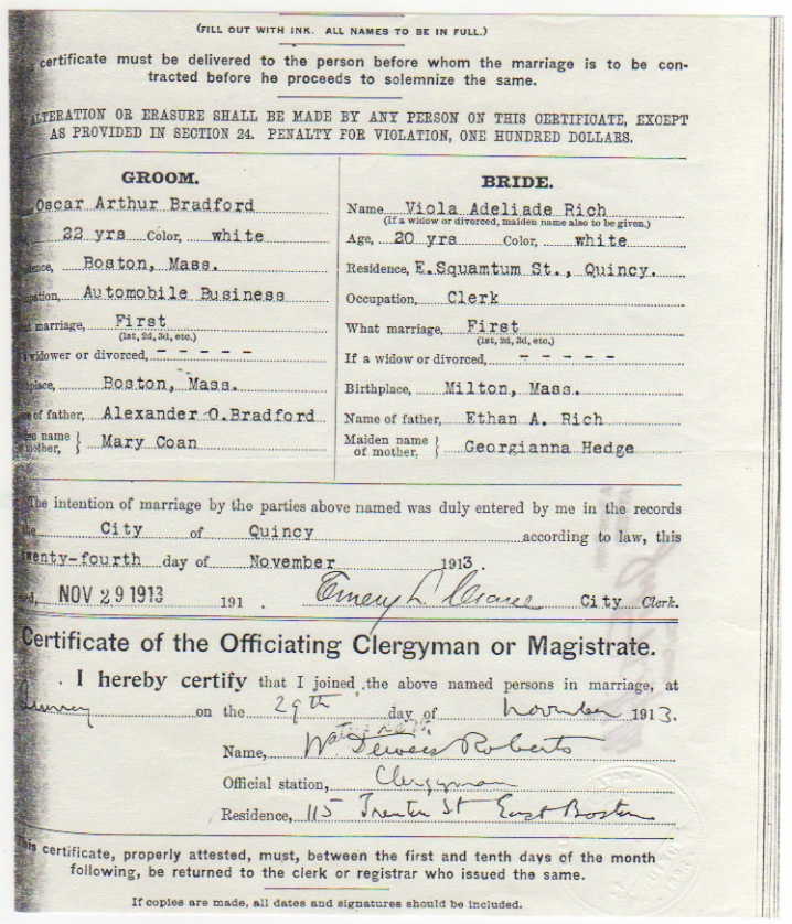
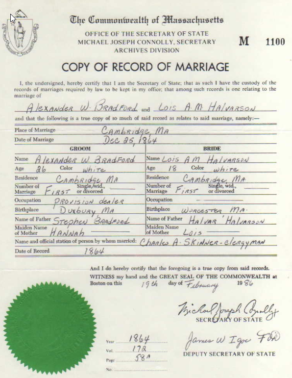
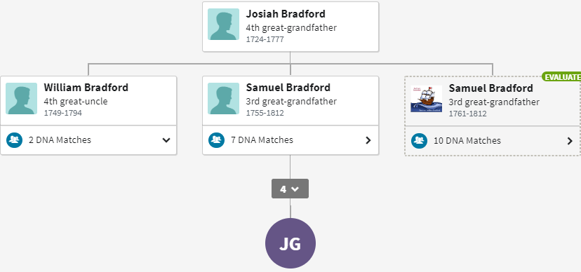
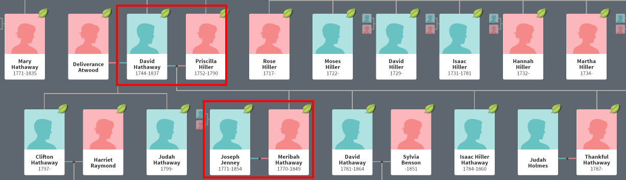
In a previous Blog, I looked at where my ancestor Joseph Hathaway lived. He was the son of David Hathaway. Here is David and family from the Wareham Town records.

If David left a will or went through probate, that will make things easier for us. I don’t see any such records yet.
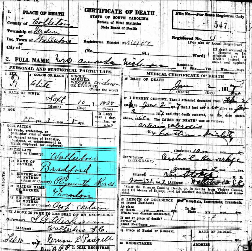
David Hathaway in the Census
Here is a David Hathaway in the 1830 Census of Wareham:

There are quite a few Hathaway’s on this page. David is living near Salathiel and Salathiel Hathaway Jr. as well as John Gurney. Here are some more names on the next page of the Wareham Census:

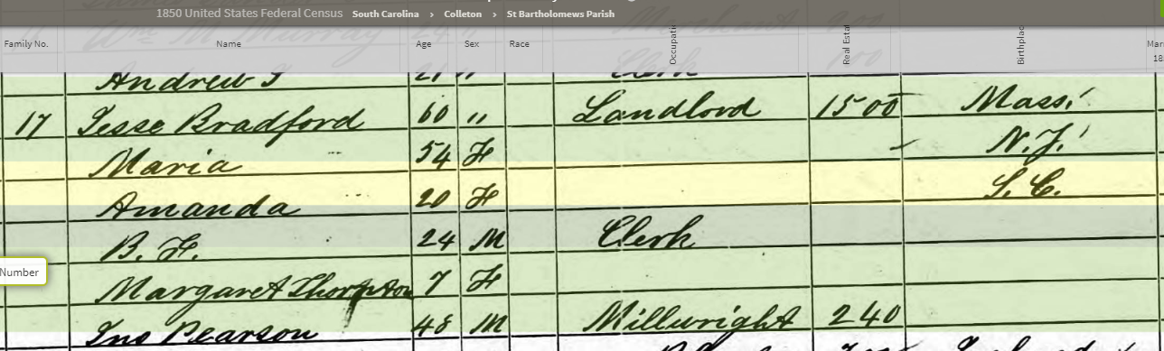
However, the above David could not be the one born in 1744:

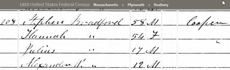
This was a man between 30 and 39 with a woman 20-29 and three children under 5 – two boys and a girl. I show later in the Blog that David sold all his Wareham property to the Town of Wareham in 1818. This could be David, son of David (1781-1864).
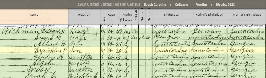
Here is the 1810 Census:

Here David is between Salathiel and Savary Hathaway. I might as well go back to 1790:

Here is a tax list from 1798. David has 90 or 98 acres of land:

I basically know that David Hathaway lived in Wareham, but I would like a more specific location.
This appears to be a deed for David Hathaway’s father Simon in Rochester:

But now I’m getting ahead of myself. This deed would have been close to when David was born on 14 October 1744. The question would be, if Simon bought a house in Rochester before David’s birth, why is David listed as born in Wareham?
Here are some more Wareham records showing David’s birth date:

Savery’s Will
It looks like Savery (or Savory), the brother of David, left a will:

This is likely the Savery listed next to David Hathaway in the 1810 Census. The will says that Savery was of Wareham. There was more of the will after this. Here is the real estate part of Savory’s inventory:

The total contains other items listed above and not reproduced here. I was hoping that there was a description of where the land was, but I didn’t see one.
To the Deeds
If there were Deeds for David Hathaway, that may be a help in locating where he was. Also I note in the records for Rochester there is a David Hathaway who dies in 1837 and one that dies in 1839. This could make life difficult. The first deed I found looks to be important:

This lists David as both a grantee and grantor which is confusing.

This deed shows that Savery and David were in Wareham and the other siblings were in Rochester. It also mentions that their father Simon had real estate in Rochester, Wareham and Plymouth. The next page relates to the dividing of the property among the three sons and describes that property:
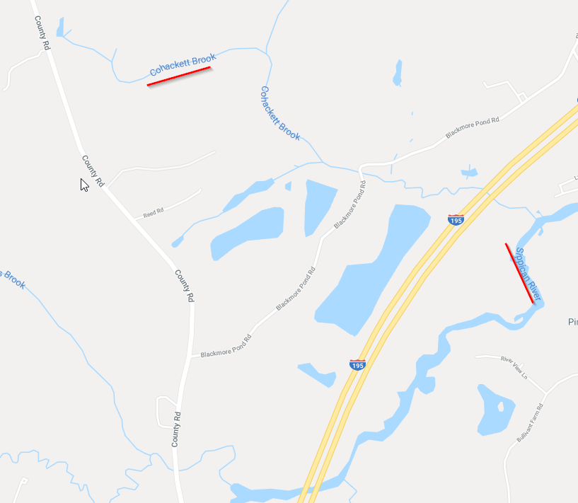
The road that divides Rochester and Wareham must be present County Road:

That perhaps narrows down where to look. There were only so many houses shown along the red shading indicating County Road above. [Edit: I should have gone further down on the map above as the current day Marion was part of Rochester at the time of the above Deed.]

This page said they had it worked out with their father as to what son would get what property. Thomas Savery is mentioned along with a school house, the Hathaway homestead, the Sippican River and the Neck between Sippican and Chokaput Creek.
Here is a map from 1832 that shows a school – possibly the one mentioned in the above deed:

However, this school on a later map is also possibly the school from the Deed:

Father Simon had also previously bought some land from Simeon Wing. My guess is that Chokaput Creek could be the present Cohackett Brook. This seems to be the same as called Cohasset Creek later in the deed. If that is right, then the Neck may be the land between the Cohackett Brook and the Sippican River:
I do notice four Hathaway houses here:

Another interesting point is that the original homestead is said to be on the West side of the road. So that would be extra credit in figuring out where that house was. Or if it was still standing at the time of the 1856 map above. From what I can tell, Savery gets the old homestead. The above deed was dated 20 April 1790 and recorded later.
The short story is that it appears that Savery gets the homestead and land. David and Simon get land. We don’t know whether any of these three lived in this area or not.
A year after this deed, my ancestor Joseph Hathaway (son of David) bought land and a house in the Pierceville area of Wareham on High Street.
Benson to David Hathaway Recorded 1803
This deed was dated 1797:

Cohasset Brook is mentioned again. That makes me think that David Hathaway was living in this area now. Perhaps this is the branch of the Cohasset? And perhaps the D. Hathaway was David the son of David Hathaway in 1856? [Edit: See later in the Blog. This was actually the home of David M. Hathaway and probably on the Marion side of the Road.]

1805 Deed Recorded 1806 Lettes Jenne to David Hathaway
Lettes Jenne sold land 56 acres of land in Rochester to David Hathaway of Wareham bordering on the land of Joseph Hathaway. I’m not really sure where this land was. Here is where I have Joseph Hathaway:

The Joseph Hathaway who was my ancestor and the son of David Hathaway lived at the top left of the Map above in the house marked R Hathaway (his daughter Ruth).
David Son of David Hathaway Deed to Savery and Alexander Hathaway 1809
This David lived in Vermont and sold land at Horse Neck (current Pierceville, Wareham) to Savery and Alexander Hathaway. This land was also near Joseph Hathaway (shown on the map above).
The next Deed is for a different (not closely related) David Hathaway who was a shipwright (and I believe a merchant) in Marion:

David Sells All His Wareham Land to the Town of Wareham 1818 for $1,000
Here is a Wareham Deed:

In a move that surprises me, David sells his house and land to the Town of Wareham:

There is specific mention of David’s Dwelling House, so it is clear that he lived at this location. He was also near a Brook, Philip, Alexander and Savory Hathaway’s land as well as Levi and George Gurney’s land. John Fearing’s land is also mentioned. This raises some questions:
- Why would the Town of Wareham want this land?
- What did David do with the money?
- Where did David live after this?
Perhaps David went into retirement in 1818. He was born in 1744, so he would have been about 72 at this point. He likely lived with one of his children. However, as per later in the Blog, he may have stayed on where he was.
Here is another deed which is difficult to explain:


From what I can tell Joseph Jenne is leasing a farm where David Hathaway lived. He is also buying David’s personal property. In exchange for this lease and personal property of David Hathaway, Joseph is conveying to the Town of Selectmen a parcel of land. I don’t know if this was an unusual arrangement:

This Joseph Jenne seems like David’s old age plan, “I the said Jenne are to take David Hathaway of Wareham aforesaid and him lawfully bed and board and clothe both in sickness and health during his the said Hathaways natural land and that the said town of Wareham are not to know any expenses on account of said David Hathaway hereafter and furthermore.” This Joseph Jenne (or Jenney) must have been the husband of Meribah Hathaway:
This is likely Joseph in the 1830 Census in Rochester:

In 1830 Joseph would have been about 59 and David about 86. The fact that Joseph was in Rochester tells me he did not remain in the leased house in Wareham. It looks like Joseph should be around the corner from my house also at the Quaker Cemetery. I’ll have to pay a visit:

Joseph Jenney to Joseph Jenney Jr
This deed has potential:


…and the said Joseph Jenney also conveys to the said Joseph Jenney Junr the Improvement of a farm situated in the Town of Wareham which I hold by virtue of a lease from the Selectmen of said Town so long as I am entitled to said possesion in consequence of said lease…”
The elder Joseph moves off the leased farm and Joseph Jenney Junior moves in (and updates the surname while he is at it). Here is Joseph Jr in 1830 at age 29:

However, he is listed as living in Rochester. So who was taking care of the Wareham farm? In 1850, Joseph is listed as a sailor but in 1855 he is a farmer. Joseph dies in 1866 in Mattrapoisett and leaves a will, but it doesn’t appear to mention the Wareham farm.
It looks like Joseph Jr. unloaded the farm and other property to his youngest brother David Jenney on 1833:


So now I’m up to 1833, but don’t see a Jenney on the map of Wareham that names people. Also the deed does not specifically mention the Wareham farm, but alludes to it by reference of the previous deed. So what happens next?
Here are some deeds for David:
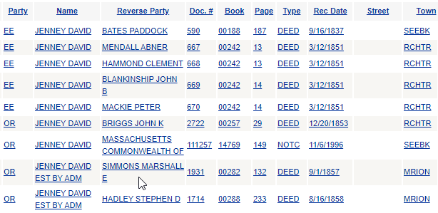
He is mostly on the receiving end (“EE”) until 1853. David dies in 1855. The last two transaction are for the Estate of David Jenney. David sold some land to John Briggs at the Great Neck in Rochester in 1851 for $3. The second sale to Simmons is for Joseph Jenney’s widow dower in or near the Old Landing in Marion. The third sale also mentions Great Neck.

I underlined the house of Mrs. D Jenney above. Here is the stone at the Old Landing Cemetery in Marion:

I’m following all this to try to figure out what happened to the David Hathaway farm. Did the farm go to Polly or did the lease just lapse?
The Will of David Jenney
I hope to find out more about the David Hathawy property here. This is all I see for real estate:

I’ve managed to lose the David Hathaway farm:
- David Hathaway sells his land and farm to the Town of Wareham in 1818
- David’s son-in-law Joseph Jenney who is married to David’s daughter Meribah leases the land from the Town of Marion about 1827
- The lease goes to Joseph Jenney Junior and then seems to get lost of lapses
David Son of Salathiel
This deed was with a different David Hathaway and involved the Northerly part of Wareham:

So that seems to be the end of deeds for the elder David Hathaway – my ancestor. There was probably no probate because he sold his house and lands to the Town of Wareham and his personal goods went to his son-in-law Joseph Jenney. For $600 Joseph sells to his son his Plymouth County real estate of every description including:
“…the improvement of a farm situated in the Town of Wareham which Should by virtue of a lease from the Selectmen of said Town so long as I am entitled to said possession in consequence of said lease…”
So, one more link in the chain of the David Hathaway house.
Summary of David Hathaway 1744-1837 So Far
David was born in 1744 to Simon Hathaway. Simon died in 1790 when David was 46 and left David and his brothers land. David’s older brother got the family house which was on the West side of present-day County Road in Rochester. Most of the land of Simon that wend to Savery, David and Simon was on the East side of County Road in Wareham. These lands were in the area of the Sippican River and Cohasset Brook which are probably the same as Chokaput Creek and today’s Cohackett Brook.
David lived to an old age. He sold his land and house to the Town of Wareham in 1808. I assume that he continued to live in this house. Around 1824, David’s son-in-law Joseph Jenne(y) leases the house and property and takes over David’s personal goods and the care of David though he seems to transfer part of that responsibility to his son Joseph Jenney Junior.
On to Simon Hathaway (1711-1790)
I’m starting to run dry on clues for David Hathaway. I’ll move on to Simon. I already mentioned the distribution of his land to his three sons above in 1790 following his death. Simon was actually born in Dartmouth and moved to Wareham before 1719. My notes say that his wife left a will.
The Will of Hannah Clifton Hathaway (1717-1808)
Hannah outlived her husband Simon by 18 years. Here is the first page of her will dated 1805:

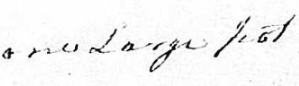
Savery gets one? large something:
David gets 25 cents as do most of the other children or heirs of the children. Hannah was said to be of Rochester. I assume that she was still living in the home of Simon which was said to be to the West of County Road, so in Rochester – or possibly current-day Marion.
The last three mentioned seemed to get more:
- Daughter Joanna gets half of her household stuff and 3/4 of her cash and notes
- Daughter Dorothy gets the other half of the household stuff and 1/4 of her cash and notes
- Philip Hathaway who was sole executor gets a cow. Philip Hathaway may be her grandson, son of her son Simon.
Simon Hathaway Deeds

Here are some pretty old deeds. This could take a while. The last deed mentions Simon Jr.
1742 Deed – That Sounds Old

This mentions that Simon was of Rochester but the land was in Wareham and bought for 130 pounds bills of Credit old Tenour.
“…a certain tract or Parcel of Land with the Haying Orchard and Fencing on the Same situate lying + being in Wareham in the County of Plymouth aforesd being the Homestead Land whereon Theophilus Doty formerly lived containing fourty acres be it more or less within the bounds following Viz. Beginning at a large Maple tree standing in a Branch of Cohasset Creek thence South by East Sixty Rods to a Stake thence West Sixty Rod to a white oak bush marked thence East by North about four Rod to a Stake by the East side of sd Way thence East by North fifty six Rods to a Pine saplin mark’d thence on a Straight Line to the maple tree first mentioned. To have and to hold the sd granted & Bargained Premises with all the appurtenances thereunto belonging unto him …”
It is not clear to me if a house stood on the property or not. The mention of the Cohasset Creek is the most helpful part as it seems to put the property in the area of present-day Cohackett Brook or at one of its branches.
1762 Family Deed at the Great Cedar Swamp
Simon Hathaway’s wife was Hannah Clifton. This deed mentions a cedar swam lot in the Great Cedar Swamp near the Joshua Cowing Homestead being the 33rd Lot in number. Charles Sturtevant and Elizabeth his wife, Timothy Clifton and Simon Hathaway owned a property in common. This deed says how they were going to split it up. Actually Sturtevant owned half and Clifton and Hathaway owned the other half.
1765 – Another Clifton Deed
Here Timothy Clifton deeds to Simon 10 acres for 40 shillings. This land was originally granted to John Cotton.
1765 – Two Deeds in a Row
In the next deed, Benjamin Johnson of Middleborough sells Simon 57 acres for 51 dollars. This deed must be for land near the original land that Simon bought in Wareham:
Bounded as follows lyning Between Theophiluy Doty’es and William Hunter’s land or land that was theirs Beginning at a pine tree old marked Near the North East Corner of Theophilus Doty’s land and then South Twenty Three degrees East Eighty five Rods to a crooked pine Tree old marked on four sides and from thence East thirteen Degrees North till we come to the Corner of Lemuel Clagon’s(?) and then Ranging by his land While We Come to a White oak Tree near the Brook the ranging as the Brook Runneth Northward to a maple Tree marked and from thence West to a Hake thence North fifty one Rods to a Hake Thence West While We come to the said Clagon’s Corner and then Ranging By his land While We Come to the pine first mentioned
This deed doesn’t mention the name Cohasset Brook, but it appears to be the same brook.
1776 A Revolutionary War Deed
In 1776 Simon purchased a wood lot in Plymouth. This appeared to be just under 180 acres. It was described as Lot 14 and belonged earlier to the heirs of Joseph Bartlett Junior.
The 1798 deed was the one that set off his land to his three sons after his death. The following deeds appear to be for Simon Hathaway Junior as they are after 1790.
More Maps Needed
Here is a portion of a map I had in my cellar from 1855 of Marion:

This is the area that I have been focusing on. In 1855, there was a David M Hathaway living on the Marion side (previously Rochester) and two Hathaways on the Wareham side of the road.
The 1855 Census shows him as a 41 year old farmer:

David M would have been born about 1814. Rebecca Hathaway would have been born about 1788.
The 1850 Census
Here is David M in 1850:

Here is the next page of the Census:

This shows that Rebecca was likely Savory Hathaway’s wife. Here is my 1855 Map again:

In 1850, Savory Hathaway was probably living in the house where J Dean was living in 1855. Savory or Savery was David M Hathaway’s father.
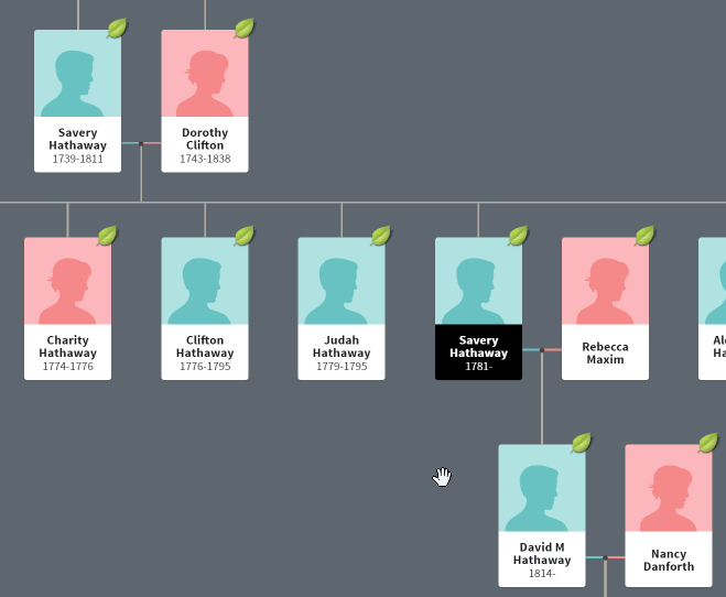
Savery’s father was also Savery and the brother of DavidHathaway, my ancestor. So it could have happened that the house passed down somehow from SImon to Savery to Savery to David M Hathaway. That ‘s the theory.
Here we see David M is the Executor:

The Second Savery Hathaway Will
I looked up Savery in the Probate Index:


Short story, Savery wants his wife taken care of. His house goes to David M Hathaway. The other children get $2 each. He wants his single daughters to have a home to live in. The judge approved this will as no one appeared to disagree with it.
I feel like I’m getting pretty close to finding out where Simon Hathaway lived. One thing that was throwing me off is that the 1858 wrongly shows D. Hathaway on the Wareham side of the Road:

It always helps to have more maps. If Savery willed his house to David M Hathaway, then he must have lived in it previously.
A Closer Look at Savery Hathaway Senior’s Will

The will is confusing as it seems to divide things evenly between the two sons Savery and Alexander. However, in the part where he gives the half to Alexander, he seems to slip in that the house would belong to Savery.

“…+ to live with my Son Savery in the old part of my Dwelling house…”
Here is Alexander’s stone along with his wife’s stone:

I haven’t looked into, but a comment on another photo said that Alexander was a Quaker preacher. I have a feeling that this cemetery is just around the corner from where I live.
That means that:
- I found David M Hathaway on a map dated 1855
- He was the son of Savery Hathaway who left the house to David M. Hathaway in his will. This Savery died 1855.
- The Savery who died in 1855 was the son of another Savery. This Savery Hathaway died in 1811 and wished his wife to live in the old part of his house with his son Savery after the elder Savery died.
Connecting Savery to Simon Hathaway
It was my sense, earlier in the Blog that the Simon Hathaway who died in 1790 left his house to Savery. Savery was the oldest son, so the house should go to him, but where does it say that?
It may help to try to write out the deed:
“We all of us proceeded to Divide the Same as we all acknowledge to have been verbally Directed by our Said Honoured father as follows, first we Began at a Stake and heap of stones standing on the East Side of the Road that parts the Town of Rochester and Wareham and to the Southward of Barn and from there Ranging East Twelve Degrees North Eighty one Rods and an half to a stake and heap of stones in the Corner of a Ditch fence, thence North thirteen Degrees East fourty four Rods to a Stake and heap of Stones which the Southwest Corner of the part hereafter set of to said David Hathaway, and thence Ranging northerly as the fence now Stands between Said David + Savery untill it comes to the Land our Said Brother Simon Bought of Thomas Savery and then Westerly by Said Simon and Said Thomas Savery Land untill it comes to the aforesaid Road, and then Bounded by Said Road to the first bound. All the Land in these Boundaries is set off and assigned to said Savery Hathaway and allso a Small piece of Wood Land on the Northerly part of the Homestead bound from the Southwesterly Corner of a Survey of Land formerly Laid oiut to Savery Crosston, thence a Straight Line to a Stake Bound of Thomas Savery Land a Little Southward of the School house and that part of the homestead Lying northward of Said Line to belong to Said Savery and also a piece of Land Lying Adjoining to Sippican River, in the Neck between Said River + Chokaput Creek Bounded from an apple tree by the Road at the Southerly End of the Barn going into Said neck, thence on a straight Line to Long Stone Standing in the Bank a bound Between two Lots of Meadow, thence Bounded by the Meadow to David Haskell’s Land and by Said Haskell’s Land to the aforesaid Road. and thence by the Road to the first Bound, all of Which Land Meadow, thence Westerly across Said Meadow + Creek to the upland, thence Bounded Bound by the Meadow taking in all the upland in Said neck up to Said Savery Hathaway Land and also a Small tract of Land near to Isaac Savery’s which our Said father Bought of John Busley Bounded as Described on the property Record all of which is Set of to Said Simon Hathaway as his Hole part of portion of Said Estate and we the…”
I’m still having trouble parsing this deed out. It appears that the first part describes the land allotted to David. The middle part starting with “and thence ranging” describes the land plotted to Savery and the homestead which belongs to Savery. The third section appears to start with “and also a piece” which is to be Simon’s allotments. I assume that Simon’s is portion is the furthest South due to mention of the Sippican River. It also appears that there is a North – South boundary between David and Savery’s properties which is difficult to picture. I don’t know how long this North – South property portion is. Also it may be that the first part doesn’t describe David’s property. It seems to follow a Northern route and then runs into a Southwestern corner of David’s land. That would make me guess that Simon has the Southern parcel, David has the Northern one and Savery has the one in the middle with the house.
Here is my guess:

More on Simon Son of SImon
According to findagrave.com, the younger Simon Hathaway died in 1799 and was buried at the Quaker Cemetery near my house in Marion:

I’ve gone this far, I might as well keep going. When the above Simon died, Philip was the oldest son and didn’t want to break up the land, so he buys out the siblings and his mom basically. That means that the land went to him. However, the land that went to him appears to have been in Rochester, not in Wareham as I would have guessed.
Simon Leads to His Son Philip
Philip died in 1841:

This s getting too complicated. While out of a run I thought of a potentially better approach.
Present to Past Approach
While out on a run, I was thinking of giving up on this Blog, but then came up with a better approach. I’ll look at the Assessor’s Maps for Wareham and perhaps Marion and then go back from there.
Here is the Wareham Assesor’s Index:

The part I want should be around the green box. The West border is County Road. The straight line going North to South must be the railway alignment. This map shows a reservoir:

That reservoir is probably from a Branch of the Cohackett:

Here is Map 65, the next Map going South:

This shows the Cohackett Brook going roughly West to East and North to South in different places. From here, I could look at one of the larger Lots. Lot 1006 is a little over 47 Acres, so I’ll start there. Now I have to figure out how to find that Lot on the Assessor’s Database. If I put in 65 for Mblu (whatever that is), I get Map 65.

I just have to track Eagle Holt Company back through time. Also I note that Ellen Harju is a popular name. There are too many Eagle Holt listings at the Registry. Hereis one for Ellen:

Ellen got the land for back taxes. This is Lot 1009 on Map 64 or 370 County Road:
 However, that was very recent. I’d like to try an older record. I’ll try Lot 1008 on Map 65:


Turns out this was also taken by the Town for non-payment of taxes. The notice mentions book 22390, page 209 at the Registry. All I have to do is find that. I think I found it and it referred to a Plan book 7 page 31. However, that document was a transfer from:

It took a while to figure this out, but I find this useful as it shows abuttors:

I just noticed that to the North of the property it says Formerly David Hathaway. The land marked as 2.22 acres was the Lot 1006 that belonged to Eagle Brook that I gave up on. That means that the former David Hathaway Property is Lot 1003, Map 65:

Also on the Barros Deed, they did mention where the Town Line crossed County Road. I can see that on this Assessor’s plan.
Here is Lot 1003:

That appears to go back to this deed:


The Deed mentions a brook in the eastern part of the property. It also mentions Book 8599, Page 349 at the Registry of Deeds:
Patricia got the property from the Resource Financial Group:

One problem is that the above document says the property is at 270 County Road and the Assessor’s Office says it is at 340 County Road.
Resource Financial got the property from Richard DeBord:

This refers to Book 7021 Page 114. I finally figured out how to view a Plan referenced also:

This shows I’m still looking at the right place. This is taking too long. I’m going to pull the plug on this avenue of research.
One ‘Last’ Idea
My last idea is to figure out who the others were living around David M Hathaway. I had good luck in figuring out who David M was. My 1855 Map of Marion shows:
R.F. Hathaway to the NE of David M and A Hathaway to the SE of David M. They should be on the 1855 Wareham Census. The Plymouth County Map shows it differently:

Here is the 1860 Census for Wareham:

The R.F. in the first plan could be Rufus F. Hathaway. Here is the 1855 Census:

In 1855, Rufus is shown living under Alexander Hathaway. Andrew was living under Nancy Hathaway. So that shows two Hathaway houses in Wareham, not three. Joshua Dean is the next one shown on the map going South to the Sippican River.
Here is Rufus:

I borrowed from other people’s trees. Apparently his middle name was Fish. Rufus was the son of Alexander. Alexander was the son of Savery. Savery was the eldest son of Simon and got the family homestead and let’s say 1/3 of the land. Perhaps Savery gave some of his land to Alexander to build a house on.
That leads mean to Savery’s will
Savery Hathaway’s (1739-1811) Will Revisited
Savery was said to be of Wareham at the time of his death. That means that if he lived in his father’s house in what was then Rochester, by the time of his death he had moved across the Road to a different house. Here is the homestead in the inventory:

This was a brief mention, but I assume that it includes all the land associated with the homestead and was a considerable amount for 1811. Another detail is that the two sons lived in different Towns:

Marion Assessors
I notice that David M Hathaway lived adjacent to the narrow area of Marion:
That should be on Marion Assessor’s Map 21:

Here is map 21 with the orientation changed:

There must have been a very large lot 6 as now it goes up to Lot 6Z. My search for County Road gave me this:

My search must have just given me County Road Lots with no numbers I assume that Block is the same as Lot? A search at the Plymouth Registry of Deeds gave many entries for 341 County Road in Marion. By the dimensions given in the deeds, this must be Lot 5:

This works also as it is in the general area I am interested in. Here is part of an 1989 deed:

This refers to a deed from 1972 and an earlier parcel referenced in 1936. Here is the 1936 deed:

This deed refers to a deed of Elizabeth F Hathaway dated March 31, 1938. The later deeds refer to the NE portion of the First Parcel in this deed. At this point I need to look for a deed or a will for Elizabeth F Hathaway. Or the 1920 Census:
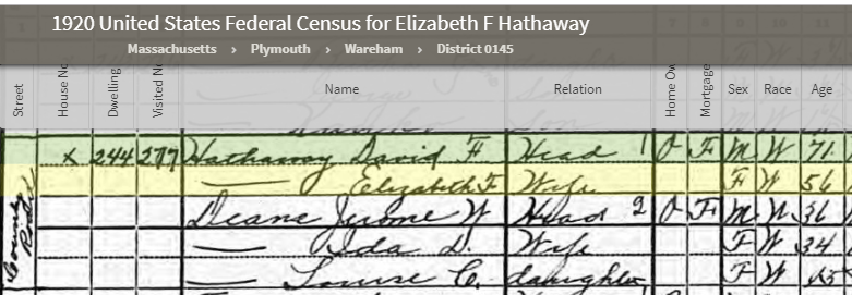
Here is Elizabeth on County Road with her husband David F Hathaway, 71 – living in Wareham.
Here is the Deed:


This mentions two parcels. The first is in Wareham and has no house. The second is across the County Road and has a house. I assume that this is where Elizabeth lived.
The 1850 Census for Rochester closes the loop:

This David F Hathaway was the son of David M Hathaway from the 1855 Plan of Marion. Marion was part of Rochester until about 1855, so David M and David F are shown as being born in Rochester. Their Rochester neighbor is Oren Vose.

David F closes the loop as far as people goes and implies a closed loop as to the inheritance of the land, but it would be a good idea to look at David M Hathaway’s Probate. I couldn’t find any but there may be deeds:

This seems to be the only one in the correct time-frame.

First I note that this deed is for Rufus F Hathaway Junior, so apparently the son of the one in the 1855 map. That explains why this Rufus is from Middleborough

Second, I note that David M Hathaway’s mother Rebecca B Hathaway is still alive at this time. Well, this could go on forever, so I’ll stop now.
Summary and Conclusions
- I set out to find out David Hathaway’s house location. I didn’t find a specific place but narrowed it down to an area of Wareham
- I did find what appears to be Simon Hathaway’s house location on a map. Simon was David’s father and my 6th great-grandfather (1711-1790).
- That location was County Road on the then Rochester (now Marion) side. On my 1855 Marion map it was likely the house marked then as David M Hathaway.
- The use of maps was most helpful in finding house locations. I found comparing maps to be helpful as not all maps are accurate.
- My ancestor David Hathaway made tracking him difficult by selling all his Wareham lands to the Town of Wareham and giving away all his personal posessions to his son-in-law Joseph Jenne(y). As a result, David had no will and no probate.
- Tracking David through deeds was helpful, but there were more than one David Hathaway in the area
- I tried started with current deeds and going back but gave up
- Given a lot more time and analysis, it may be possible to narrow down David’s house location more precisely.